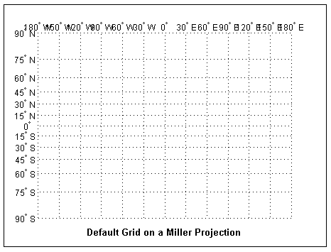
Map Grid
The map
grid is the set of displayed meridians and parallels, also known as
a graticule. Display the grid by setting the
axesm-based map property Grid to
'on'. You can do this when you create
axesm-based maps with axesm, with
setm, or with the direct command gridm
on.
Control Grid Spacing
To control display of meridians and parallels, set a scalar meridian spacing or a
vector of desired meridians in the MLineLocation property. The
property PLineLocation serves a corresponding purpose for
parallels. The default values place grid lines every 30° for meridians and every 15°
for parallels.
Layer Grids
By default, the grid is placed as the top layer of any display. You can alter this
by changing the GAltitude property, so that other map objects
can be placed "above" the grid. The new grid is drawn at its new altitude. The units
used for GAltitude are specified with the daspectm function.
To reposition the grid back to the top of the display, use the command
gridm reset. You can also control the appearance of grid
lines with the GLineStyle and GLineWidth
properties, which are ':' and 0.5,
respectively, by default.
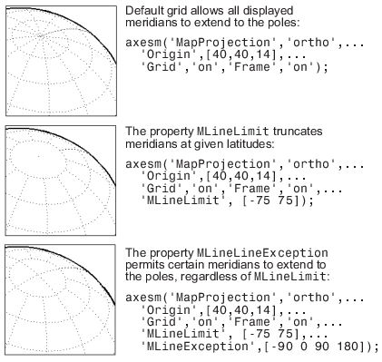
Limit Grid Lines
The Miller projection is an example in which all the meridians can extend to the
poles without appearing to be cluttered. In other projections, such as the
orthographic (below), the map grid can obscure the surface where they converge. Two
axesm-based map properties, MLineLimit
and MLineException, enable you to control such clutter:
Use the
MLineLimitproperty to specify a pair of latitudes at which to terminate the meridians. For example, settingMLineLimitto[-75 75]completely clears the region above and below this latitude range of meridian lines.If you want some lines to reach the poles but not others, you can specify them with the
MLineExceptionproperty. For example, ifMLineExceptionis set to[-90 0 90 180], then the meridians corresponding to the four cardinal longitudes will continue past the limit on to the pole.
The use of these properties is illustrated in the figure below. Note that there
are two corresponding axesm-based map properties,
PLineLimit and PLineException, for
controlling the extent of displayed parallels.
Label Grids
You can label displayed parallels and meridians. MeridianLabel
and ParallelLabel are on-off properties for displaying labels on
the meridians and parallels, respectively. They are both 'off' by
default. Initially, the label locations coincide with the default displayed grid
lines, but you can alter this by using the PlabelLocation and
MlabelLocation properties. These grid lines are labeled
across the north edge of the map for meridians and along the west edge of the map
for parallels. However, the property MlabelParallel allows you
to specify 'north', 'south',
'equator', or a specific latitude at which to display the
meridian labels, and PlabelMeridian allows the choice of
'west', 'east',
'prime', or a specific longitude for the parallel labels. By
default, parallel labels are displayed in the range of 0° to 90° north and
south of the equator while meridian labels are displayed in the range of 0° to
180° east and west of the prime meridian. You can use the mlabelzero22pi function to redisplay the meridian labels in the
range of 0° to 360° east of the prime meridian.
Properties affecting grid labeling are listed below.
Property | Effect |
|---|---|
| Toggle display of meridian labels |
| Toggle display of parallel labels |
| Alternate interval for labeling meridians |
| Alternate interval for labeling parallels |
| Keyword or latitude for placing meridian labels |
| Keyword or longitude for placing parallel labels |
| Relabel meridians with positive angle from 0° to 360° |
For complete descriptions of all axesm-based map properties,
refer to the axesm-Based Map Properties reference
page.