patchm
Project patches on axesm-based map
Syntax
h = patchm(lat,lon,cdata)

h
= patchm(lat,lon,cdata,PropertyName,PropertyValue,...)

h = patchm(lat,lon,PropertyName,PropertyValue,...)

h = patchm(lat,lon,z,cdata)

h
= patchm(lat,lon,z,cdata, PropertyName,PropertyValue,...)
Description
h = patchm(lat,lon,cdata) and
h
= patchm(lat,lon,cdata,PropertyName,PropertyValue,...)
project
and display patch (polygon) objects defined by their vertices given in
lat and lon on the current
axesm-based map. lat and
lon must be vectors. The color data, cdata,
can be any color data designation supported by the standard MATLAB®
patch function. The object handle or handles, h,
can be returned.
h = patchm(lat,lon,PropertyName,PropertyValue,...)
allows any property name/property value pair supported by patch to be
assigned to the patchm object. Except for XData,
YData, and ZData, all line properties and
styles available through patch are supported by
patchm.
h = patchm(lat,lon,z,cdata) and
h
= patchm(lat,lon,z,cdata, PropertyName,PropertyValue,...)
allow
the assignment of an altitude, z, to each patch object. The default
altitude is z = 0.
Examples
Project coastline data as single patch object on a map.
load coastlines
axesm sinusoid;
framem
h = patchm(coastlat,coastlon,'b');
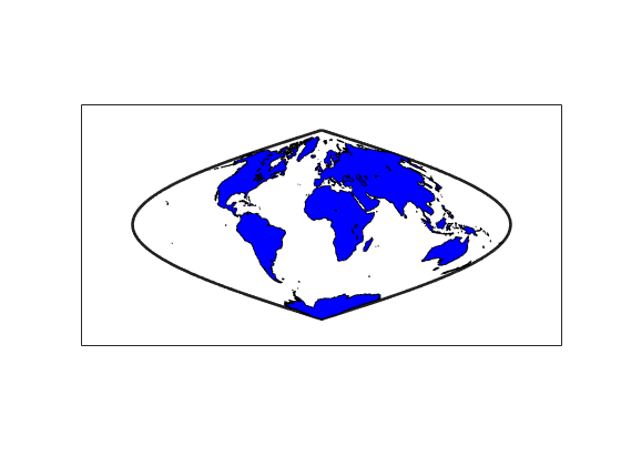
length(h)
ans =
1
Tips
How patchm Works
This Mapping Toolbox™ function is very similar to the standard MATLAB
patch function. Like its analog, and unlike higher level
functions such as fillm and fill3m,
patchm adds patch objects to the current
axesm-based map regardless of hold state.
When A Patch Is Completely Trimmed Away
Removing graphic objects that fall outside the map frame is
called trimming. If, after trimming to the map frame no polygons remain
to be seen within it, patchm creates no patches
and returns an empty 0-by-1 handle. When this occurs, automatic reprojection
of the patch data (by changing the projection or any of its parameters)
will not be possible. Instead, after changing the projection, call patchm again.
Version History
Introduced before R2006a