Coordinate Systems for Blocked Images
R2026bA blocked image is an image whose data is divided into a grid of blocks, enabling you
to process each block independently. MATLAB® represents blocked images by using the blockedImage object. A blocked image establishes a relationship between
these coordinate systems.
Pixel subscripts — Specify the row and column of each pixel in an image or block. In a blocked image, each pixel has a global pixel subscript, which defines its position in the entire image, and a local pixel subscript, which defines its position in its block.
Block subscripts — Specify the row and column of each block in the grid of blocks.
World coordinates — Specify locations in a continuous spatial coordinate system. This coordinate system can represent real-world units.
As these coordinate systems represent the same image data, you can use conversion functions to switch between them..
Pixel locations are expressed using subscripts of the form (row, column). For a general overview of pixel subscripts and image coordinate conventions, see Image Coordinate Systems.
Pixel Subscripts and Block Subscripts
A blockedImage object represents an image organized as a grid of
discrete blocks. The object identifies each block using a set of block subscripts
that specify its location in the block grid, equal in number to the number of
dimensions in the original image. For example, a grayscale image might have blocks
with subscripts of the form (row, column), while an RGB image might have blocks with
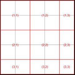
subscripts of the form (row, column, channel). This illustration shows a 5-by-5
image divided into blocks of size 2-by-2, with blocks and their subscripts overlaid
in red on the gray pixel grid.
Note
If the blocks do not fit exactly over the image,
blockedImage creates partial blocks at the edges. These
edge blocks might be smaller than the specified block size. When processing
blocked images, you can specify whether to pad the partial blocks at the
edges of images.
When using the
applyfunction to process ablockedImage, you can pad the partial blocks into blocks of full size by specifying thePadPartialBlocksname-value argument astrue.A
blockedImageDatastorePadPartialBlocksproperty of theblockedImageDatastoretofalse.
Unlike numeric image arrays, you cannot directly index into a
blockedImage object using array syntax. For example, given a
blockedimage object bim, you cannot specify
bim(row,column). Instead, to access and process blocked image
data, you must use blockedImage object functions such as getBlock, getRegion, setBlock, and crop.
For more information about the available object functions, see blockedImage.
Note that a blocked image can be a multilevel image, which contains multiple levels where each level represents the same image at a different resolution. Each level can have its own block size. If the user specifies a single block size when creating a multilevel blocked image, this block size is applied to all levels.
Convert Between Pixel Subscripts and Block Subscripts
To determine which block contains a given pixel, use the sub2blocksub function.
For example, suppose that a blocked image, bim, corresponds
to a 5-by-5 blocked image with 2-by-2 blocks. The pixel with subscripts (3, 2)
lies in block (2, 1).
blockIndex = sub2blocksub(bim,[3 2])
blockIndex =

     2     1
To determine the range of pixels in a given block, use the blocksub2sub function. This function returns the subscripts of the
top-left and bottom-right pixels in the block.
For example, calling blocksub2sub on
bim with the block subscripts (2, 1) returns the
subscripts of the pixels in the top-left corner (3, 1) and bottom-right corner
(4, 2) of that block.
[pStart,pEnd] = blocksub2sub(bim,[2 1])
pStart =

     3     1


pEnd =

     4     2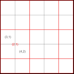
For multilevel images, you can specify which resolution level the subscripts
refer to when calling sub2blocksub and
blocksub2sub by specifying the Level
argument.
Convert Local Pixel Subscripts to Global Pixel Subscripts
When you process blocks using the apply object function,
the function uses pixel subscripts local to each block. For example, if you
identify a feature within the block, such as by detecting a peak, the resulting
indices are pixel subscripts local to that block, not the full image.
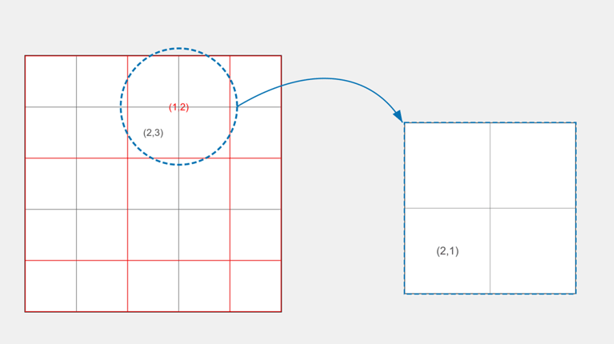
For example, suppose that you have a 5-by-5 blocked image with 2-by-2 blocks. The pixel with global subscripts (2, 3) is in the block with subscripts (1, 2). Within that block, the same pixel has the local subscripts (2, 1).
The function you pass to apply accepts a structure that
contains the data and metadata for each block. The Start
field of each structure must contain the global pixel subscripts of the top-left
corner of the corresponding block. To convert a local position to global pixel
subscripts, add the local subscript to the block origin and subtract 1:
globalSub = blockInfo.Start + localSub - 1
For example, if the blockInfo.Start value for block (1, 2)
is [1 3], and you detect a feature at local position
[2 1] within the block, the global pixel subscript of
that feature is [1 3] + [2 1] – [1 1] = [2 3].
Pixel Subscripts and World Coordinates
Some applications, such as measuring distances, aligning images, or locating pixels based on physical coordinates, can require you to describe image locations in continuous units rather than discrete pixel indices. In these cases, use world coordinates.
blockedImage objects express world coordinates in a continuous
coordinate system using (y, x) order, where y corresponds to rows and x corresponds
to columns. This order matches the (row, column) convention used for pixel
subscripts. In this coordinate system, x increases from left to right and y
increases from top to bottom.
Note
The order (y, x) for world coordinates differs from other functions in Image Processing Toolbox™, which use an (x, y) order for world coordinates. For more information, see Image Coordinate Systems.
World coordinates provide a continuous spatial coordinate system that is independent of the image pixel grid. You can assign physical meaning to image data by defining pixel spacing and spatial extent in real-world units.
A blockedImage object defines the mapping between pixel
subscripts and world coordinates using the WorldStart and
WorldEnd properties:
WorldStart— Specifies the world coordinates of the outer boundary of the pixel at the top-left corner of the image.WorldEnd— Specifies the world coordinates of the outer boundary of the pixel at the bottom-right corner of the image.
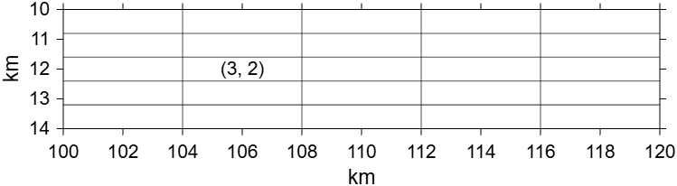
For example, consider a 5-by-5 blocked image, bimworld, that
represents a geographic region that spans 4 km in the y-direction and 20 km in the
x-direction. The outer boundary of the top-left pixel has world coordinates (10,
100), and the outer boundary of the bottom-right pixel has world coordinates (14,
120). In this image, each pixel spans 0.8 world units in the y-direction and 4.0
world units in the x-direction. To create bimworld, use a
WorldStart value of [10 100] and a
WorldEnd value of [14 120].
The center of the pixel with subscripts (3, 2) in bimworld has
world coordinates (12.0, 106.0). Conversely, the world coordinates (12.1, 105.0) lie
within the pixel with subscripts (3, 2).
To convert between pixel subscripts and world coordinates:
You can use the sub2world function to compute the world
coordinates worldc of the center of the pixel with subscripts (3,
2) in bimworld. Since the input array represents pixel
subscripts, it must be
integer-valued.
worldc = sub2world(bimworld,[3 2])
worldc =

   12.0000  106.0000
You can use the world2sub function to determine the
subscripts of the pixel pixelsub that contains the world
coordinates (12.1, 105.0) of
bimworld.
pixelsub = world2sub(bimworld,[12.1 105])
pixelsub =

     3     2
The function world2sub rounds up world coordinate values on the
edge of two pixels, except for pixels on the border, where it rounds down to the
last pixel.
If you pass world coordinates that fall outside the image extent,
world2sub clamps the result to valid pixel subscripts.
Coordinates before WorldStart map to subscript 1, and
coordinates beyond WorldEnd map to the last pixel in that
dimension. The function does not error or return NaN for
out-of-bounds input. For instance, for bimworld,
running
pixelsub = world2sub(bimworld,[20 106])
pixelsub =

     5     2
For higher-dimensional images, world coordinates extend to additional dimensions.
For multilevel images, blockedImage assumes that all levels
correspond to the same real-world spatial extents, derived from the finest
resolution level. Pixel subscripts map to different world coordinates at different
levels because each pixel covers a greater world extent at coarser levels. While the
sub2world and world2sub functions
convert based on pixel subscripts at the finest resolution level by default, you can
specify the Level name-value argument to specify which resolution
level to use for the conversion. For information on defining the spatial referencing
of your data consistently across levels, see Set Up Spatial Referencing for Blocked Images.
See Also
blockedImage | blocksub2sub | sub2blocksubsub2worldworld2sub

