worldGrid
Description
[,
where X,Y] = worldGrid(R,gridOption)gridOption is "gridvectors", returns
X and Y as row vectors. The coordinates of
raster element (i,j) are (X(j),Y(i)). The default for
gridOption is "fullgrid", which returns
X and Y as 2-D arrays.
Examples
Import elevation data, find the coordinates of the imported data, then display the data as a surface.
First import elevation data [1] for an area around Mount Washington as an array and a map cells reference object. Prepare the data for plotting by specifying the output type as "double".
[Z,R] = readgeoraster("MtWashington-ft.grd",OutputType="double");
Find the coordinates of each element in the array.
[X,Y] = worldGrid(R);
Display the elevation data as a surface using an appropriate colormap. Set the EdgeColor property to "none" to remove the mesh from the surface.
surf(X,Y,Z,EdgeColor="none") demcmap(Z) xlabel("x (meters)") ylabel("y (meters)") zlabel("Elevation (feet)")

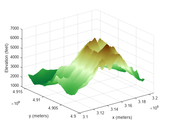
[1] The elevation data used in this example is courtesy of the U.S. Geological Survey.
Create a map cells reference object for a 3-by-4 raster with x values in the range [7000, 7400] meters and y values in the range [2700, 3300] meters. Get the coordinates of the raster elements and return them as row vectors.
R = maprefcells([7000 7400],[2700 3300],[3 4]);
[X,Y] = worldGrid(R,'gridvectors')X = 1×4
7050 7150 7250 7350
Y = 1×3
2800 3000 3200
If you do not specify the second argument as 'gridvectors', then the worldGrid function returns 2-D arrays by default.
[xFull,yFull] = worldGrid(R)
xFull = 3×4
7050 7150 7250 7350
7050 7150 7250 7350
7050 7150 7250 7350
yFull = 3×4
2800 2800 2800 2800
3000 3000 3000 3000
3200 3200 3200 3200
Input Arguments
Spatial reference, specified as a MapCellsReference or MapPostingsReference object.
If R is a MapCellsReference object, then
X and Y are cell centers. If
R is a MapPostingsReference object, then
X and Y are posting points.
Grid option, specified as one of these values:
"fullgrid"— ReturnXandYas 2-D arrays, where each row ofXis identical and each column ofYis identical. This is the default behavior."gridvectors"— ReturnXandYas row vectors. Use this option when you want to reduce memory usage and when 2-D arrays are unnecessary, such as when plotting large data sets with thesurffunction. You can specifygridOptionas"gridvectors"only when theTransformationTypeproperty ofRhas a value of"rectilinear".
This table shows the difference between "fullgrid" and
"gridvectors".
"fullgrid" | "gridvectors" |
|---|---|
R = maprefcells([7000 7400],[2700 3300],[3 4]); [X,Y] = worldGrid(R) X =
7050 7150 7250 7350
7050 7150 7250 7350
7050 7150 7250 7350
Y =
2800 2800 2800 2800
3000 3000 3000 3000
3200 3200 3200 3200 |
R = maprefcells([7000 7400],[2700 3300],[3 4]);
[X,Y] = worldGrid(R,"gridvectors")X =
7050 7150 7250 7350
Y =
2800 3000 3200
|
Data Types: char | string
Output Arguments
x-coordinates, returned as a 2-D array or a row vector. By
default, X is a 2-D array. To return X as a
row vector, specify gridOption as
"gridvectors".
By default, and when gridOption is
"fullgrid", the sizes of X and
Y each equal the RasterSize property of
R. When gridOption is
"gridvectors", the lengths of X and
Y equal the second and first elements of the
RasterSize property of R,
respectively.
y-coordinates, returned as a 2-D array or a row vector. By
default, Y is a 2-D array. To return Y as a
row vector, specify gridOption as
"gridvectors".
By default, and when gridOption is
"fullgrid", the sizes of X and
Y each equal the RasterSize property of
R. When gridOption is
"gridvectors", the lengths of X and
Y equal the second and first elements of the
RasterSize property of R,
respectively.
Version History
Introduced in R2021a
See Also
Functions
Objects
MATLAB Command
You clicked a link that corresponds to this MATLAB command:
Run the command by entering it in the MATLAB Command Window. Web browsers do not support MATLAB commands.
Seleccione un país/idioma
Seleccione un país/idioma para obtener contenido traducido, si está disponible, y ver eventos y ofertas de productos y servicios locales. Según su ubicación geográfica, recomendamos que seleccione: .
También puede seleccionar uno de estos países/idiomas:
Cómo obtener el mejor rendimiento
Seleccione China (en idioma chino o inglés) para obtener el mejor rendimiento. Los sitios web de otros países no están optimizados para ser accedidos desde su ubicación geográfica.
América
- América Latina (Español)
- Canada (English)
- United States (English)
Europa
- Belgium (English)
- Denmark (English)
- Deutschland (Deutsch)
- España (Español)
- Finland (English)
- France (Français)
- Ireland (English)
- Italia (Italiano)
- Luxembourg (English)
- Netherlands (English)
- Norway (English)
- Österreich (Deutsch)
- Portugal (English)
- Sweden (English)
- Switzerland
- United Kingdom (English)