aoicircle
Syntax
Description
Numeric Data
aoi = aoicircle(lat,lon,radius)
Examples
Read the geographic coordinates of European capitals into the workspace. Specify the geographic CRS as the World Geodetic System of 1984, which has the EPSG code 4326.
[lat,lon] = readvars("european_capitals.txt");
gcrs = geocrs(4326);
Create an AOI of circles from the geographic coordinates. Specify the radius of each circle as 2 degrees. When you pass geographic coordinates to the aoicircle function, the function represents the AOI using a scalar polygon shape in geographic coordinates.
aoi = aoicircle(lat,lon,2,gcrs)
aoi =
  geopolyshape with properties:

              NumRegions: 6
                NumHoles: 0
                Geometry: "polygon"
    CoordinateSystemType: "geographic"
           GeographicCRS: [1×1 geocrs]
Display the AOI and the capitals on a map.
geobasemap topographic
geoplot(aoi)
hold on
geoplot(lat,lon,"k.",MarkerSize=10)

Specify the projected coordinates for several places in Boston. Specify the projected CRS for the points as NAD83 / Massachusetts Mainland, which has the EPSG code 26986.
x = [236266 235743 234685 232989 236536 234591 235741 237114 235741 236548];
y = [900974 900355 901429 901884 901901 901892 900663 900670 900725 899587];
pcrs = projcrs(26986);
When you pass projected coordinates to the aoicircle function, you must specify the radius of each circle using the length unit of the projected CRS. Find the length unit. The result indicates that you must specify radius in meters.
pcrs.LengthUnit
ans =
"meter"
Create an AOI of circles. Specify the circle centers using the projected coordinates, and specify the radius of each circle as 200 meters. When you pass projected coordinates to the aoicircle function, the function represents the AOI using a scalar polygon shape in projected coordinates.
aoi = aoicircle(x,y,200,pcrs)
aoi =
  mappolyshape with properties:

              NumRegions: 8
                NumHoles: 0
                Geometry: "polygon"
    CoordinateSystemType: "planar"
            ProjectedCRS: [1×1 projcrs]
Display the AOI on a map.
geobasemap streets
geoplot(aoi)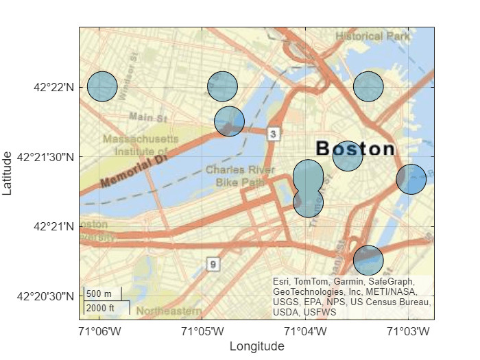
Create a geospatial table by geocoding several Australian cities. The table represents the cities using point shapes in geographic coordinates.
cities = ["Adelaide","Melbourne","Canberra","Sydney","Brisbane"];
GT = geocode(cities,"city");
GT.Shape
ans =
  5×1 geopointshape array with properties:

               NumPoints: [5×1 double]
                Latitude: [5×1 double]
               Longitude: [5×1 double]
                Geometry: "point"
    CoordinateSystemType: "geographic"
           GeographicCRS: [1×1 geocrs]
Create an AOI of circles from the shapes in the geospatial table. Specify the radius of each circle as 3 degrees. When you pass data in geographic coordinates to the aoicircle function, the function represents the AOI using a scalar polygon shape in geographic coordinates.
aoi = aoicircle(GT,3)
aoi =
  geopolyshape with properties:

              NumRegions: 2
                NumHoles: 0
                Geometry: "polygon"
    CoordinateSystemType: "geographic"
           GeographicCRS: [1×1 geocrs]
Display the AOI and the cities on a map.
geoplot(aoi)
hold on
geoplot(GT,"k.",MarkerSize=20)

Specify the projected coordinates for several places in Boston. Specify the projected CRS for the points as NAD83 / Massachusetts Mainland, which has the EPSG code 26986.
x = [236266 235743 234685 232989 236536 234591 235741 237114 235741 236548];
y = [900974 900355 901429 901884 901901 901892 900663 900670 900725 899587];
pcrs = projcrs(26986);
Create a point shape object from the coordinates and projected CRS.
shape = mappointshape(x,y);
shape.ProjectedCRS = pcrs;
When you pass projected coordinates to the aoicircle function, you must specify the radius of each circle using the length unit of the projected CRS. Find the length unit. The result indicates that you must specify the radius in meters.
pcrs.LengthUnit
ans =
"meter"
Create an AOI of circles from the point shape. Specify the radius of each circle as 300 meters. When you pass data in projected coordinates to the aoicircle function, the function represents the AOI using a scalar polygon shape in projected coordinates.
aoi = aoicircle(shape,300)
aoi =
  mappolyshape with properties:

              NumRegions: 6
                NumHoles: 0
                Geometry: "polygon"
    CoordinateSystemType: "planar"
            ProjectedCRS: [1×1 projcrs]
Display the AOI and the places on a map.
geoplot(aoi)
hold on
geobasemap topographic
geoplot(shape,".k",MarkerSize=10)

Create a point shape in geographic coordinates that represents Paris, France. Specify the geographic CRS as the World Geodetic System of 1984, which has the EPSG code 4326.
shape = geopointshape(48.86,2.35);
shape.GeographicCRS = geocrs(4326);
Create an AOI from the point shape. Specify the radius as 0.5 degrees.
aoi = aoicircle(shape,0.5);
Create a geospatial table from the AOI. Then, export the geospatial table to a shapefile by using the shapewrite function.
aoiGT = table(aoi,VariableName="Shape");
filename = "parisAOI.shp";
shapewrite(aoiGT,filename)
Read the shapefile into the workspace, and view the AOI.
GT = readgeotable(filename);
geobasemap topographic
geoplot(GT)
Input Arguments
Output Arguments
More About
Version History
Introduced in R2024b