Main Content

local2globalcoord

Convert local to global coordinates

Description

gCoord = local2globalcoord(lclCoord) converts the local rectangular coordinates lclCoord to the global rectangular coordinates gCoord.

example

gCoord = local2globalcoord(lclCoord,option) converts local coordinates to global coordinates using the coordinate transformation type option.

example

gCoord = local2globalcoord(___,localOrigin) specifies the origin of the local coordinate system localOrigin. Use this syntax with any of the input arguments in previous syntaxes.

example

gCoord = local2globalcoord(___,localAxes) specifies the axes of the local coordinate system localAxes. Use this syntax with any of the input arguments in previous syntaxes.

Examples

collapse all

Convert local rectangular coordinates to global rectangular coordinates. The local coordinate origin is (1, 1, 1).

globalcoord = local2globalcoord([0;1;0],"rr",[1;1;1])
globalcoord = 3×1

     1
     2
     1

Convert local spherical coordinates to global rectangular coordinates.

globalcoord = local2globalcoord([30;45;4],"sr")
globalcoord = 3×1

    2.4495
    1.4142
    2.8284

Convert two vectors from global to local coordinates using the global2localcoord function. Then convert them back from local to global coordinates using the local2globalcoord function.

Start with two vectors in global coordinates, (0, 1, 0) and (1, 1, 1). The local coordinate origins are (1, 5, 2) and (-4, 5, 7), respectively.

gCoord = [0 1;1 1;0 1]
gCoord = 3×2

     0     1
     1     1
     0     1

lclOrig = [1 -4;5 5;2 7];

Construct two rotation matrices using the rotation functions.

lclAxes(:,:,1) = rotz(45)*roty(-15);
lclAxes(:,:,2) = roty(45)*rotx(35);

Convert the vectors from global coordinates to local coordinates.

lclCoord = global2localcoord(gCoord,"rr",lclOrig,lclAxes)
lclCoord = 3×2

   -3.9327    7.7782
   -2.1213   -3.6822
   -1.0168    1.7151

Convert the vectors from local coordinates back to global coordinates.

gCoord1 = local2globalcoord(lclCoord,"rr",lclOrig,lclAxes)
gCoord1 = 3×2

   -0.0000    1.0000
    1.0000    1.0000
         0    1.0000

Input Arguments

collapse all

Local coordinates in rectangular or spherical coordinate form, specified as a 3-by-N matrix. Each column represents one set of local coordinates.

If the coordinates are in rectangular form, each column contains the (x,y,z) components. Units are in meters.

If the coordinates are in spherical form, each column contains (az,el,r) components. az is the azimuth angle in degrees, el is the elevation angle in degrees, and r is the radius in meters.

Data Types: double

Type of coordinate transformation, specified as a string scalar or character vector. Specify one of the following values.

ValueTransformation
"rr" or 'rr'Local rectangular to global rectangular
"rs" or 'rs'Local rectangular to global spherical
"sr" or 'sr'Local spherical to global rectangular
"ss" or 'ss'Local spherical to global spherical

Data Types: string | char

Origin of the local coordinate system, specified as a 3-by-N matrix containing the rectangular coordinates of the local coordinate system origin with respect to the global coordinate system. N must match the number of columns of gCoord. Each column represents a separate origin. Alternatively, you can specify localOrigin as a 3-by-1 vector. If you do so, localOrigin expands to a 3-by-N matrix with identical columns.

Data Types: double

Axes of the local coordinate system, specified as a 3-by-3-by-N array. Each page contains a 3-by-3 matrix representing axes for a different local coordinate system. The columns of the 3-by-3 matrices specify the local x, y, and z axes in rectangular form with respect to the global coordinate system. Alternatively, you can specify localAxes as a single 3-by-3 matrix. If you do so, localAxes expands to a 3-by-3-by-N array with identical 3-by-3 matrices. The default value is the identity matrix.

Data Types: double

Output Arguments

collapse all

Global coordinates in rectangular or spherical coordinate form, returned as a 3-by-N matrix. The dimensions of gCoord match the dimensions of lclCoord. The origin of the global coordinate system is assumed to be (0, 0, 0). The global system axes are the standard unit basis vectors in three-dimensional space, (1, 0, 0), (0, 1, 0), and (0, 0, 1).

Data Types: double

More About

collapse all

Azimuth and Elevation Angles

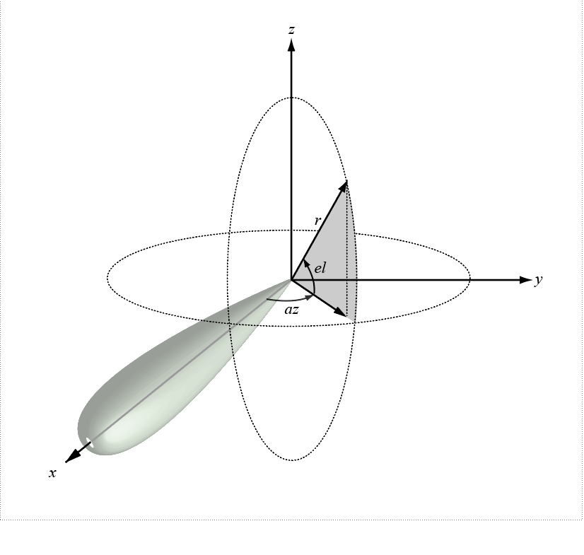
The azimuth angle of a vector is the angle between the x-axis and the orthogonal projection of the vector onto the xy-plane. The angle is positive from the x-axis toward the y-axis. Azimuth angles lie between –180 and 180 degrees. The elevation angle is the angle between the vector and its orthogonal projection onto the xy-plane. The angle is positive toward the positive z-axis from the xy-plane. By default, the boresight direction of an element or array is aligned with the positive x-axis. The boresight direction is the direction of the main lobe of an element or array.

Note

The elevation angle is sometimes defined as the angle a vector makes with the positive z-axis. The MATLAB® and Phased Array System Toolbox™ products do not use this definition.

This figure illustrates the azimuth and elevation angles of a direction vector.

References

[1] Foley, J. D., A. van Dam, S. K. Feiner, and J. F. Hughes. Computer Graphics: Principles and Practice in C, 2nd Ed. Reading, MA: Addison-Wesley, 1995.

Extended Capabilities

Version History

Introduced in R2011a